Maps can be an engaging tool to help deepen our students’ understanding of Israel. In its short history, the borders of the state have been in a constant state of flux, regularly negotiated and fought over. Many major events in Israeli history, such as the Partition Plan, the Six-Day War and the Oslo Accords, need to be understood by considering their impact on the map. Moreover, maps can be used to bring to life the challenges of establishing and maintaining a thriving Jewish state in a complex region.
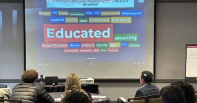
As we try to differentiate instruction for students with different strengths and interests, maps can be a great tool to engage visual learners who find it easier to understand information when it is presented as an image or graphic. That is why we, at Unpacked for Educators, have created this helpful maps resource for you to utilize in your classroom.
Here are five practical activities for you to teach about Israel using maps
1. The Power of Maps
Trigger activity
Some maps are not designed to depict reality but to shape it. In the following activity students will break down two propaganda maps. The purpose of this activity is to demonstrate to students that many maps are not neutral and objective but reflect different narratives and aspirations, whether subtly or overtly.
Show your students each of the following maps in turn and ask them these questions:
- Who created / might use this map?
- What is the narrative that this map is promoting?
Map 1 This map was published in 1934 by Keren Tel Chai, a fund associated with the Revisionist Zionist movement.
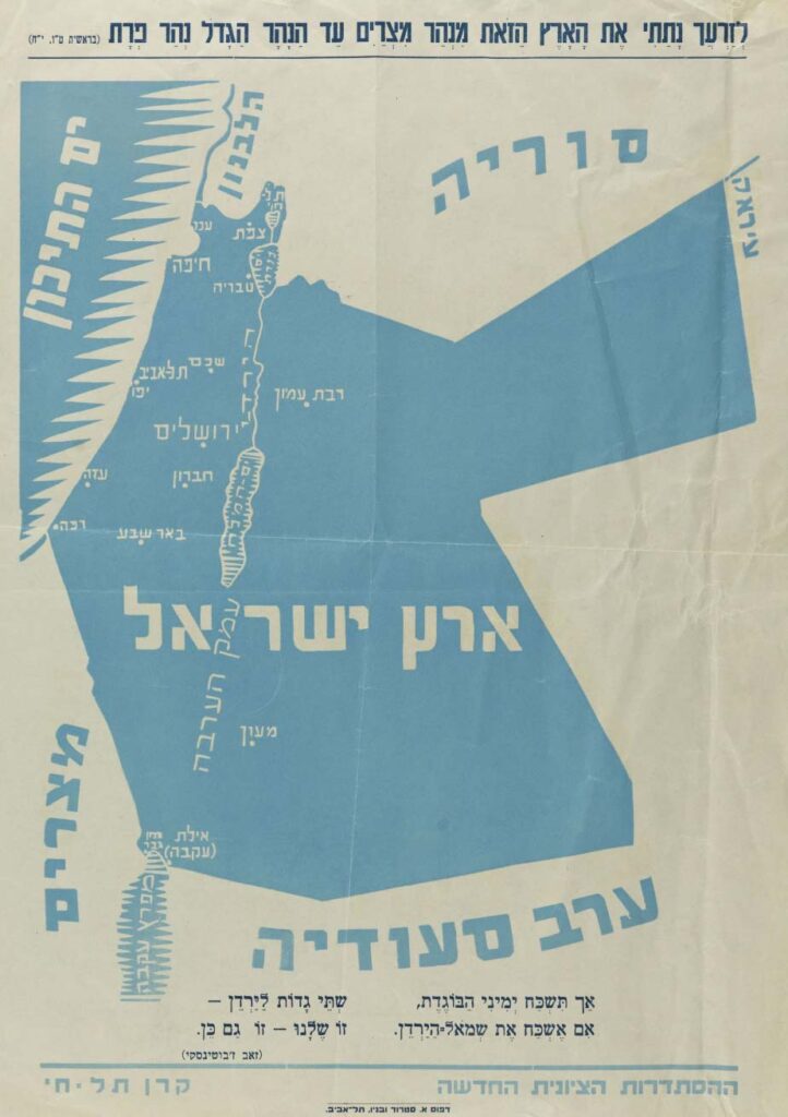
Source: web.nli.org.il
Map 2 This map, omitting the State of Israel, appeared on the Palestinian Authority website.

Source: jewishvirtuallibrary.org
Discussion
- Is there such a thing as an objective map?
- Do all maps of Israel convey a certain narrative?
- Why is it important to understand who created a map and what its purpose is?
- Consider Map 10 – Current Day Israel in the maps resource.
- Which areas are included in the map?
- What is shaded and what is not?
- Do you agree with this portrayal of the map of Israel?
- Do you think everyone would agree with this presentation of the map? Why or why not?
2. What’s In A Name?
Trigger activity
The labels used to describe a territory are just as significant as its boundaries. Use this activity as a trigger to discuss the complexity surrounding the West Bank / Judea and Samaria (Yehuda v’Shomron), Israeli settlements, the realities of Jewish and Palestinian life in the West Bank, or the security barrier.
Ask your students to share different names they have heard associated with the territory shaded in light purple on Map 10 – Current Day Israel in the maps resource . Write the names on the board.
(Ex: West Bank, Disputed Territories, Judea and Samaria (Yehuda v’Shomron), Occupied Territory, Palestinian Territory, Palestine)
Discuss
- What political opinion (right-wing, left-wing, anti-Israel…) could each term signify?
(ex: “Yehuda v’Shomron” highlights the historic Jewish connection to this area which goes back to biblical times, “Occupied Territory” could imply that Israel is there illegally.)
For further learning, teach students about the history of this territory by utilizing Map 7 – Six-Day War 1967 in the maps resource and the accompanying videos.
3. Maps Jigsaw Activity
Learning activity
The history of the State of Israel can be understood through its evolving map. In this activity, students will learn and then teach each other about important historical maps of Israel and thereby gain a deeper understanding of important moments in Israeli history.
Divide your students into groups of four. Have each student in the group choose a different map from the maps resource (alternatively, you can assign four maps you want them to focus on, we’d recommend Map 5 – Partition Plan 1947, Map 6 – Armistice Lines 1949, Map 7 – Six-Day War 1967, and Map 9 – Oslo Accords 1995).
Students should individually read the blurb of their chosen map then and watch one of the Unpacked videos associated with their map. Students must then answer the following questions:
- What does the map show?
- What events are important in order to understand this map?
- How do you think different stakeholders (Israelis, Palestinians, etc.) feel about this map?
Students should then take turns explaining their chosen map to the other members of their group by sharing their answers to these questions.
4. Israel in Tanach (Bible)
Learning activity
The Jewish connection to the Land of Israel dates back to biblical times. According to the Tanach, God promised the land to Abraham, Joshua conquered the land and King David ruled it. In this interdisciplinary Israel education and Tanach activity, we will consider the significance of the Jewish people’s religious and historical connection to the land.
- Ask your students to compare Map 1 – Biblical Israel and Map 10 – Current Day Israel in the maps resource.
- Ask students to write a list of five similarities and differences between the two maps.
- Ask a few students to share their findings with the class.
- Then, discuss the following question: Why has the modern State of Israel chosen to use many biblical names for cities, towns or regions?
- Show students the following video: The True Origins of Modern Zionism
Discuss- Is Zionism a new or an old movement?
- Does it matter if Zionism is an old or a new movement?
- Text study: Ask your students to complete this worksheet about the borders of the land as promised by God to Avraham, in chavruta (pairs).
5. Contextualizing Anti-Israel Maps
Summative task
Maps can be used to push a certain narrative. In this activity, students are asked to break down a classic anti-Israel map by contextualizing it. This activity should be used as a summative task or discussion with students who have completed a comprehensive study of Israeli history and the map.
After teaching students about the history of Israel’s borders (especially Map 5 – Partition Plan 1947, Map 6 – Armistice Lines 1949, Map 7 – Six-Day War 1967, and Map 9 – Oslo Accords 1995 in the maps resource), show them the following anti-Israel map. Have your students respond to the following prompts in writing or as part of a class discussion.
- Which elements of the arrangement of maps are accurate?
- Which elements of the arrangement of maps are misleading?
- Do you think this arrangement of maps is a fair or unfair presentation of the history of the conflict? Explain your answer in detail.
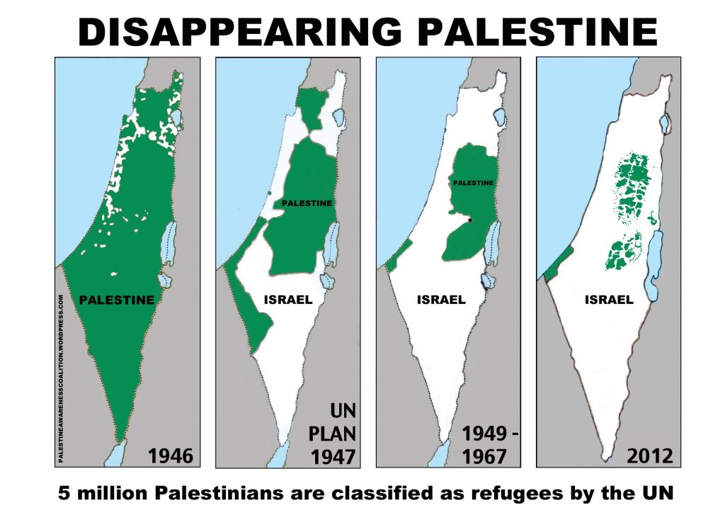
Source: timesofisrael.com